700+ Verified Lands · 4 Cities · Live data
Why 100+
developers
subscribed in 3
months.
If your next project needs Joint Development or outright land, the pipeline you'd otherwise build over 6 months is already on the map.
 BengaluruChennaiPune
( More cities coming soon..)

· No spam. We message you on WhatsApp once.
· GST invoice on every payment.

Enter your name and WhatsApp number above to unlock the walkthrough.


Ratna Kiran
Co-founder
Right now we're helping 30 firms close ~₹5,000 crore in land deals. We can only do this kind of hands-on work for a few firms at a time.
The Developer Dashboard is how we help everyone else. It puts 8-10 new parcels in front of you, every day. Pick what fits your project on your own.
Live inventory
What's inside, today.
700+ verified parcels across 4 cities. 8-10 added every working day.
Explore by city:

Active listings
266
Last 30 days
+43 new
Joint Development
56
Outright
210
Size range
472 Sq Yards - 183 Acres 11 Guntas
Single-parcel to industrial-scale aggregations
Daily velocity
8-10 new lands every working day
Plus emerging inventory in Nagpur, Jaipur, Mysuru, Visakhapatnam (under 10 lands per city, growing).
The layers
Weeks of diligence, in minutes.
The walkthrough shows these layers stack in 30 seconds. Here's what each one tells you, and what it saves you from chasing.
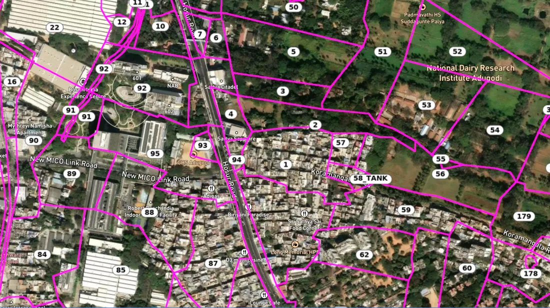
Survey number and cadastral boundary, on the satellite.
The parcel's survey number is labelled on its cadastral boundary, drawn over the satellite. You see the official shape and survey number before you visit.
What this saves?
A revenue-office trip for the survey records, and a virtual site visit before the real one.
Sitemap, digitised and laid on satellite map.
The site sketch from the owner, digitised by the GIS team and laid cleanly on the satellite map. You see the parcel's exact boundary, its frontage, and its access. No guesswork about where the parcel actually starts and ends.
What this saves?
Getting the site map from the owner, and matching it to satellite map on your own.
Site Map

Sy. 142/3
340'
280'
390' road
Owner's Sketch
Digitised on satellite

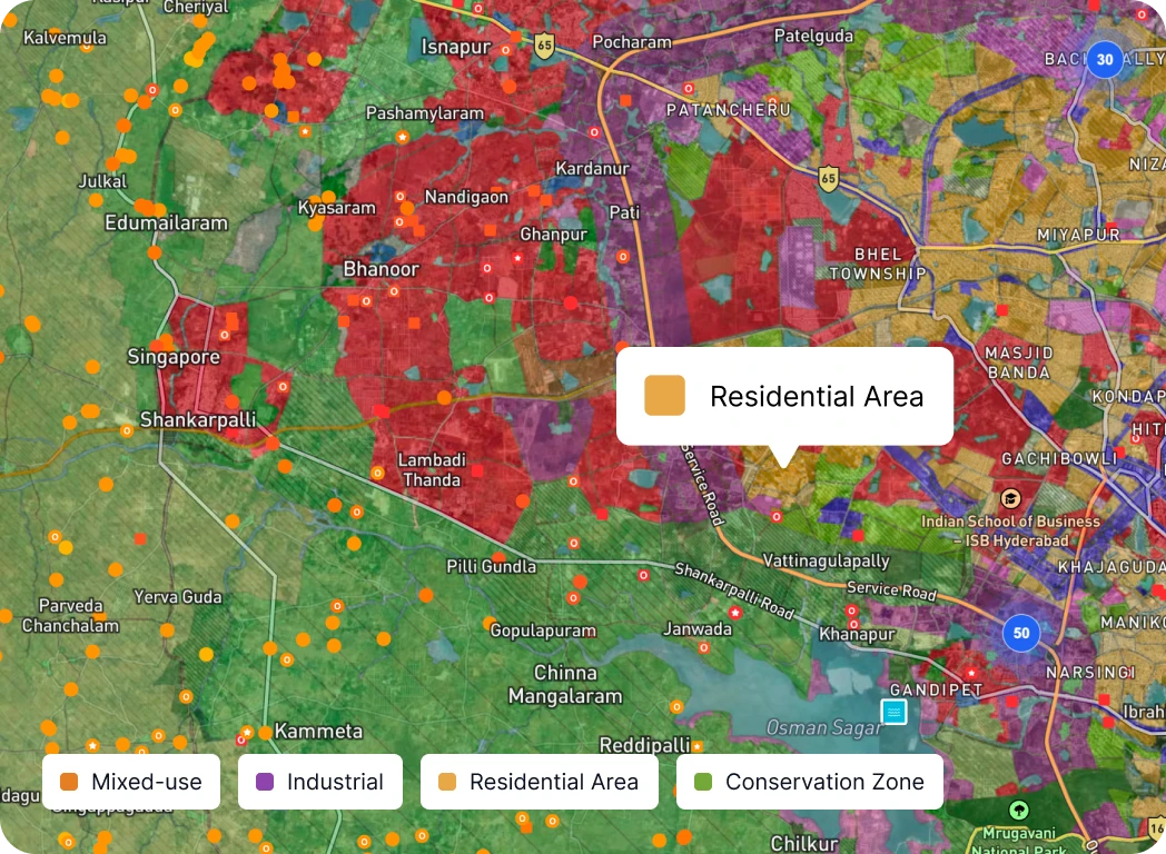
Master plan zoning, underneath the parcel.
HMDA in Hyderabad, BMRDA in Bengaluru, CMDA in Chennai, PMRDA in Pune. The relevant master plan tile sits under the parcel boundary at the right scale, so the zoning is readable at parcel level.
The parcel tells you what's legally buildable: residential, mixed-use, commercial, industrial, or agricultural zone.
What this saves?
Sourcing and reading the master plan down to parcel level. Or hiring a zoning consultant.
Master plan road width, layered on the parcel.
The master plan's proposed road width layers on the parcel, while the listing mentions the actual road width today.
What this saves?
A master plan portal trip, and the road widening math after it.

Parcel · 7.2 acre


Existing road · 80 ft
Master plan · 150 ft
Road width
80 → 150 ft
Today → Master plan
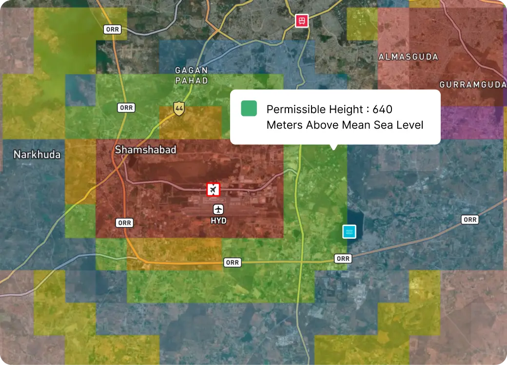
Air funnel ceiling by location
Listings near airports are checked against the AAI and IAF permissible height map. The number you see is the meters you can legally go up, from the Mean Sea Level (MSL).
What this saves?
Filing your own NOC application. Most developers learn the ceiling exists after they've already chosen the parcel.
Owner terms, posted on the listing card
Click any pin and the listing card opens. Outright deals show the asking price. Joint development deals show the revenue split, the advance, and the kind of project type the owner prefers. Posted by the owner or their agent. So your first call is the real one.
What this saves?
The 'call for details' runaround, and the meetings wasted on deals that don't fit your project.
Deal type
Joint Development
Split
70 : 30
Refundable SD
₹3.5 cr
Term
36 mo
Deal type
Outright purchase
Price / acre
₹2.8 cr
Extent
14 ac
Token
₹10 lakh
Each of these takes days to find on its own. Together, weeks. Here, on one screen.
methodology
A parcel passes 4 checks before it goes live.
Here's exactly what our verification team checks. And the work that stays with you.
Land Match
Parcel location lines up with the survey number boundaries on the state cadastral map. Land on the ground must match the survey number on paper.
Extent Match
Declared extent matches official documents (digital records). For multi-survey parcels, each survey number and subdivision is verified individually. Totals must add up.
Restriction-level Flags
Nature-of-land, tenure, and other-rights columns checked for legal blockers and government restrictions.
Sketch Match
The seller's site plan is cross-verified against the cadastral sketch and survey boundaries on record. Plot layouts, sub-division splits, and adjacent boundaries must match.
What you need to check
Chain of title beyond the seller's documents, boundary disputes with neighbours, pending revenue mutations, tax arrears, building bye-laws / FSI compliance, and more depending on the parcel. You close these with your lawyer.
— METHODOLOGY
A parcel passes 4 checks before it goes live.
Here's exactly what our verification team checks. And the work that stays with you.
Location Match
Parcel location lines up with the survey number boundaries on the state cadastral map. Land on the ground must match the survey number on paper.
Extent Match
Declared extent matches official documents (digital records). For multi-survey parcels, each survey number and subdivision is verified individually. Totals must add up.
Restriction-level Flags
Nature-of-land, tenure, and other-rights columns checked for legal blockers and government restrictions.
Sketch Match
The seller's site plan is cross-verified against the cadastral sketch and survey boundaries on record. Plot layouts, sub-division splits, and adjacent boundaries must match.
What you need to check
Chain of title beyond the seller's documents, boundary disputes with neighbours, pending revenue mutations, tax arrears, building bye-laws / FSI compliance, and more depending on the parcel. You close these with your lawyer.
Already subscribed
Some of the developers sourcing on the map
— ALREADY SUBSCRIBED
Some of the developers sourcing on the map
Pricing
Two plans. Same
access.
Pay once a year, or test with a quarter.
Yearly · per user
Save ₹30,000₹50,000/ year
Equivalent of ₹12,500 a quarter. Pay once, work all year.
Both plans include
- Verified lands across Hyderabad,
Bengaluru, Chennai, Pune - 300+ Data layers on latest satellite map
- Sitemap superimposed on satellite
- Owner terms on each JD listing
- GST invoice on every payment
- Cancel quarterly anytime before the
next quarter
What this isn't
Not advisory. Not transaction support. The Developer Dashboard is a self-serve tool. For named-deal sourcing or transaction structuring, that is a separate engagement.
Common questions about pricing
Want a walkthrough first? .
— PRICING
Two plans. Same access
Pay once a year, or test with a quarter.
Yearly · per user
Save ₹30,000₹50,000/ year
Equivalent of ₹12,500 a quarter. Pay once, work all year.
Quarterly · Per user
₹20,000/ quarter
Try a quarter. Full access. Upgrade to yearly any time.
Both plans include
- Access to verified lands across all prime cities
- 300+ Data layers on latest satellite map
- Sitemap superimposed on satellite
- Owner terms on each JD listing
- GST invoice on every payment
What this isn't
Not advisory. Not transaction support. The Developer Dashboard is a self-serve tool. For named-deal sourcing or transaction structuring, that is a separate engagement.
Common questions about pricing
Want a walkthrough first? .
FAQ
Questions developers actually ask.
— FAQ
Questions developers actually ask
closing
If your next projectneeds land inHyderabad, Bengaluru,Chennai, or Pune,subscribe to Developer Dashboard today.
— CLOSING